Sprague's Pier
Gallery
img
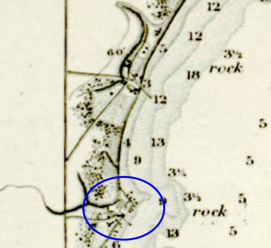
The location of Spragues Pier on the 1866 Lake Michigan Coastal Chart
 
Attraction
Description
Sprague's Pier, otherwise known as the Sprague & Owen Pier or Robert's Pier, is located within the exclusion zone of the Kewaunee Power Station. The pier was one of the earliest, and the smallest, of the private commercial piers established in Kewaunee County in the mid- to late-19th century.

Between 1851 and 1854, James Madison Sprague and his partner John J. Owen financed construction of a small steam-powered sawmill at the mouth of the shallow creek that empties into the lake on the south side of the point. Sprague and Owen were absent owners in the venture. Sprague, in particular, divided his time between Racine, where his wife Mary had family ties (she was the daughter of Gilbert Knapp, founder of Racine), and Manitowoc County.

The partners hired Hiram Cogswell and Adolph Manseau, two lumbermen from Two Rivers, to manage and operate the mill and pier. A small force of workmen lived and worked at the mill site, cutting and hauling timber products such as cordwood, tanning bark, and shingles and preparing them for shipping. The forest products were picked up by lake schooners and taken south to Milwaukee, Chicago, and other port cities.

Following a series of lawsuits, in 1860 the Sprague's Pier property was seized and auctioned off to cover Sprague and Owen's debts. Among the creditors suing the partners was Sprague's own brother-in-law, Gilbert Knapp.

Later accounts, on lost references and local lore, indicate that after the conclusion of the final lawsuit, the property was transferred into the ownership of Joseph Vilas, another Manitowoc lumberman, and then into the hands of former fisherman George R. Roberts. Roberts is mentioned as retrofitting a pier at "Stony Point" prior to the spring shipping season in 1871. Later newspaper accounts suggest that he was manufacturing shingles and lumber, but his occupation is listed as "farmer" on the 1870 census records for Carlton Township. If the pier was in operation, it was shipping very little and at small enough scales to fly under the radar of local press. By 1875, Roberts had left the area and was living in Ahnapee (now Algoma).

The pier's location is attested to only by the 1866 and 1877 coastal charts of Lake Michigan, which shows a relatively small pier on the south side of the prominent point, one mile south of the Sandy Bay Pier and two miles north of the pier and tannery complex at Two Creeks. A single building is shown at the base of the pier, presumably denoting the complex's sawmill.
 
Map
 
Nearby
© 2026 - Wisconsin Sea Grant, Wisconsin Historical Society