Wisconsin is nearly surrounded by water, and water is everywhere in between, with thousands of inland lakes and thousands of miles of rivers and streams. In fact, a quarter of Wisconsin lies underwater! No matter which direction we may travel in our state, we find a waterway. A waterway is deep and wide enough for people to navigate a boat. Smaller waterways such as creeks or ponds may be only large enough for a small boat, like a canoe. The Great Lakes are large enough that huge ships can travel upon them. For thousands of years, people have used waterways, large and small, to travel and move their goods.
People used resources like fish and plants found in and around waterways. Wisconsin’s waterways provided transportation and trade routes for Native people. Later, these same waterways were helpful to the settlers in the 1800s. These settlers became Wisconsin’s miners, lumberjacks, manufacturers and farmers. Waterways have been used to help transport goods to market here and elsewhere and receive goods needed from other places around the world. They have been used to generate power for industry, and many people have enjoyed recreation and vacations on Wisconsin’s lakes and rivers. Wisconsin’s larger waterways are still major shipping lanes. By learning about Wisconsin’s waterways and how people have used them, we learn much about the way people have lived and worked here.
Melting Glaciers Create Lakes
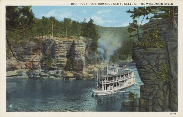
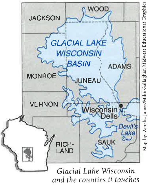
Melting glaciers created ponds and lakes. Some existed only as long as the glaciers were around. A glacial lake formed when huge blocks of ice, rock, and gravel held a glacier’s melting water. Glacial Lake Wisconsin was the largest, once covering much of what are now Adams, Juneau, Jackson, Monroe, and Wood Counties. As temperatures warmed, the ice that blocked Glacial Lake Wisconsin melted, and the water rushed out. It flowed swiftly and cut into the surfaces of the sandstone north and west of Baraboo. Over time, this water erosion formed the huge rock formations that became known as the Wisconsin Dells.
The glaciers also left Wisconsin with thousands of lakes that we see today. When huge piles of drift blocked the mouths or the ends of valleys, water collected behind them. Devil’s Lake near Baraboo and the four lakes around Madison were formed this way. Sometimes large amounts of ice got trapped under the glacial drift. When the ice melted, it created a low area or kettle that filled with water. Most of Wisconsin’s smaller ponds or lakes are kettle lakes. Glaciers also created the Great Lakes. The enormous weight of glaciers deepened the basins of what are now Lakes Superior, Michigan, Huron, Erie and Ontario. When the glaciers melted, these very deep basins filled with water. Together the Great Lakes stretch about 1,000 miles across the United States and Canada and contain 20 percent of the world’s drinkable water. The Great Lakes are one of the most important waterways in the world.
Wetlands
Wisconsin’s waterways also provide important habitats or places where fish and aquatic plants live beneath the surface of the water. Some of the lakes were so shallow that aquatic vegetation slowly filled them. We call these areas wetlands because they are covered or saturated with water for all or part of the year. The thick plant life in wetlands also serves as a welcoming habitat for many wild creatures. Horicon Marsh and many other wetlands of the state were once shallow glacier-dammed lakes like Glacial Lake Wisconsin. Like a sponge, wetlands keep harmful things from getting into the waterways like pollutants, eroded or washed away soil, and floodwater. Wetlands covered much of the state before European and Euro-American settlers drained the land for agriculture.
Rivers and Their Watersheds
Water has the amazing ability to transform the land around it. Water drains from the land into the nearest wetland and waterway. Marshes, ponds, lakes, streams, and rivers are all examples of waterways. The areas of land that drain into one waterway form a watershed. As a smaller stream flows into a larger waterway, the land drains. The smaller stream is called a tributary. Each tributary that flows into a larger waterway increases that waterway’s size. Large Rivers and their tributaries form river systems. All of Wisconsin’s River systems and their watersheds drain into three major waterways: the Mississippi River, Lake Superior, or Lake Michigan.
From: Wisconsin Our State, Our Story and Working with Water: Wisconsin’s Waterways.